
Fully Structured and Classified Road Network for use in Navigation Systems


In 1993, Terra has begun the production of the road network geographical database of Greece which since then it constantly maintains and updates. Terra is now the proprietor of the country’s most up-to-date navigable road network database of scale 1:5,000, totaling to a 320,404 km in length.
Navigable is the road network with the main feature the streets and interconnections connectivity. Other characteristics of the navigable road network are road category, direction, speed and network restrictions (for example, a U-turn restriction).
Each road network database feature contains in addition street name, street numbering, and road category information.
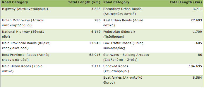
The roads classification of and the total length of each category are shown in the table below:
The Address Geographical Database is a derivative product of the road network which is available as a stand-alone product. The accuracy of the address database is better than 1.5 meters for urban areas and better than 3 meters for rural areas. It contains about 1,700,000 distinct addresses and covers the entire country.
View here the geographic extent of the road network and address database which covers 433 towns & villages with full navigation data and 303 towns & villages with street names only.