
3D Data Models


We live in a three dimensional world. The need for a multitude of human activities led the respective sciences to make efforts to better understand their subject by modeling our 3D world with the help of computers. These activities concern the management of the environment, the construction of technical works, the architecture, the design of outdoor spaces, landscaping, the exploration of the seas and also the seemingly irrelevant activities such as archeology, navigation, telecommunications, supply chain, warehouse management even marketing and sales.
In recent decades, the use of three-dimensional models has been limited to mainly visualization purposes. However, they are now increasingly being used in a wide range of tasks beyond visualization.
Basic 3D Applications Areas
The basic spatial questions that these models answer that apply to all of the above activities are:
- Slope: Calculate the slope of the ground at the points of the surface
- Line of Sight: calculates whether there is an obstacle between two points
- Elevation: Determination of the altitude in an area
- Contour Lines: Creating and displaying contour curves
- Shadowing: Determining the shadow coverage of the volume of an object during the day
- Calculating the volume of an object (e.g. a building, mountain, or some earthwork)
- Visualization: three-dimensional visualization of an object or an area
- Inventory: Automatic identification of individual elements of a building / object
Digital Terrain Models
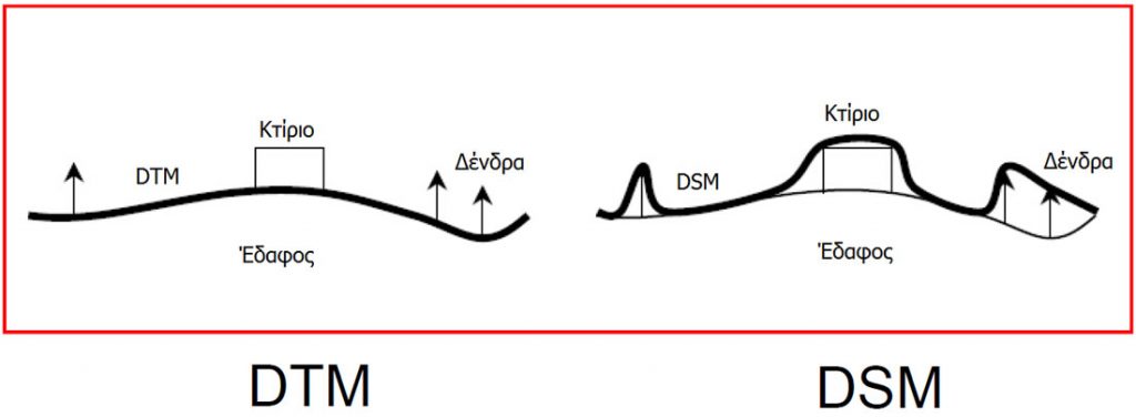
Digital terrain models (DTMs) are three-dimensional digital models that simulate the ground surface.
In Terra we make the following distinction:
- DTM (Digital Terrain Model): refers to the altitude (ground height from the sea surface)
- CEM (City Elevation Model) or 3D buildings: altitude model referring to the height of buildings from the ground
- DSM (Digital Surface Model): DTM + height of objects on the ground such as buildings, trees, cars. Because the objects we are most interested in are the buildings, DSM can be defined as DTM + CEM
Their difference is best seen in the following picture:
Terra produces, maintains and updates digital models for the whole country. At present, digital terrain models (DTM) are of horizontal accuracy of 12.5 meters and last update date is 2011. CEM are of horizontal and vertical accuracy less than a meter and cover the areas of selected big cities & small towns of Greece with last update date 2017.
Data Collection
Data collection is done with Contemporary Image Taking & Processing Platforms and with on the field collection. Collection platforms include satellite shots, aerial photography (A/F) and unmanned aerial vehicles (UAV), usually drones. All platforms are equipped with the appropriate digital sensors giving accuracy less than one meter. Terra is in partnership with local offices of large foreign companies providing satellite data (from the Iconos, WorldView, QuickBird, GeoEye and Pleiades satellites), aerial photographs and has proprietary drones for direct and high-quality production of small geographic area digital models such as for example the city of Agrinio.
At the same time, and in particular for the collection of urban geospatial data, Terra maintains field crews equipped with the appropriate equipment (GPS, iPads, Collectors) to collect and update both 3D and 2D data helping in the creation of digital models.
Data processing
Using photogrammetric methods both automatically during the photographs’ shooting and with office equipment two types of data formats are typically created: true ortho-photos and Digital Models (DTM, DSM, and CEM).
In several cases, the collected data is contrasted with existing ones and the geographic database is updated only where necessary, resulting in a reduction in processing time and production costs. This comparison of the new with the existing data is done by a combination of image processing techniques with advanced algorithms (aero-triangulations, DTM, oblique images) and identifies new buildings, floor extensions, changes in road network and land use.
Database Maintenance
In each activity, the final result is directly related to the input data. The same happens with your software. As good as it may be, if you feed it with incomplete or invalid data, the result you get will be unreliable.
Trust your results using Terra’s valid geographic bases and improve planning of your business activities, making your materials and human resources more efficient while lowering costs.
Terra recognizing the added value of its geospatial base in making decisions at any level of your organization, provides you with additional database maintenance services according to the quality assurance process of our company that consists in general of the following steps:
- Data production methodology
- Geographical data quality control
- Data update
- Data accuracy
Utilization of a spatial model
Digital models are usually divided into three categories depending on the level of detail:
- Small scale (country level)
- Medium-scale (city-level) and
- Large scale (object, interior space)
They are managed with the following (high level) workflow process “model creation > storage > visualization and use”.
The management and utilization of these models are either made the available by GIS software or via development of new software that can be built and implemented on various programming platforms. Our company can advise you on the appropriate build-in model or create the one you want.