

Integrated Urban Geographic Data Recording & Management System

The term “smart city” is used to describe a city that uses up-to-date technologies to improve the daily lives of its citizens, and to enhance their participation in decision-making process on issues that concern them. The goal of all modern cities is eGovernment services, easy movement, rich and open data free to citizens, direct and accurate information, information and functionality and, of course, reduction of energy consumption and protection of the environment.
SmartOTA is a Contemporary Data Recording & Management Platform and is primarily addressed to Local Government Organizations. It has been implemented with state-of-the-art cloud GIS technology that allows it to be used by certified organizations through a web browser without any investment in hardware or software.
It offers a wide range of services with a geographic representation of the local government and understandable “dashboards”, where the key performance indicators appear in one screen in the form of aggregate tables and diagrams. Performance indices provide functionalities for direct supervision of the organization for all activities supported by the platform including financial data.
Display on a single screen the number and categories of lighting lamps in your area of responsibility, monitor the evolution of the street lighting upgrade project, schedule project implementation and ensure the absorption of the funds.
The integrated SmartOTA platform offers services in the following 10 areas:
- City Guide: promotion services and visitor services (attractions and sightseeing, municipal service points, municipal services, business promotion, complaints recording)
- Lighting Recording and Study Design: Record the lighting equipment with the SmartOTA Data Acquisition subsystem, measure lighting by road category, locate problematic lighting points and compile documented lighting suggestions / studies designs
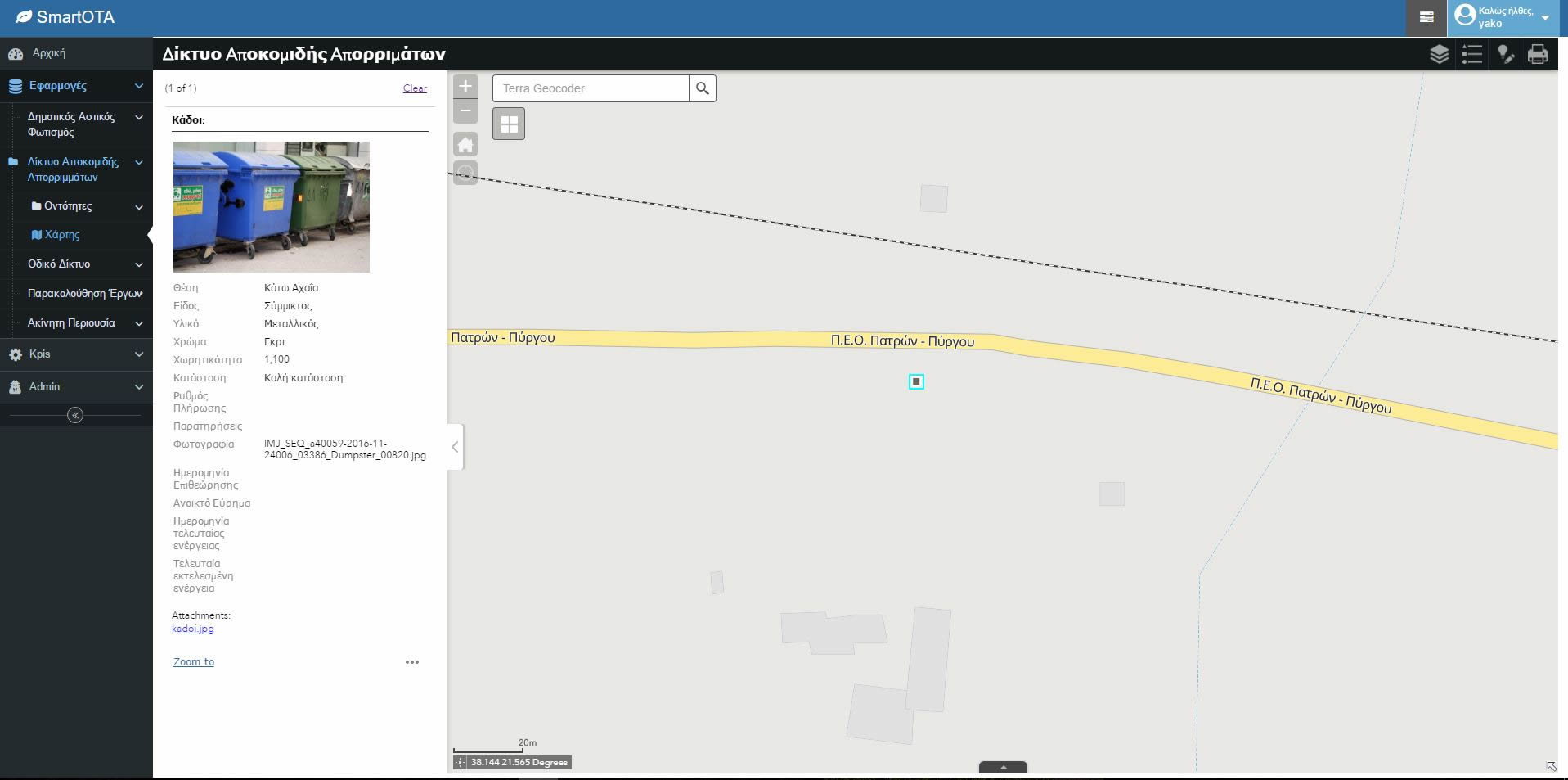
- Waste Management – Municipal Cleansing Services: record garbage collection points, manage garbage collection fleet, organize and optimize your human and material resources, raise environmental awareness and reward your citizens, reduce your operating costs
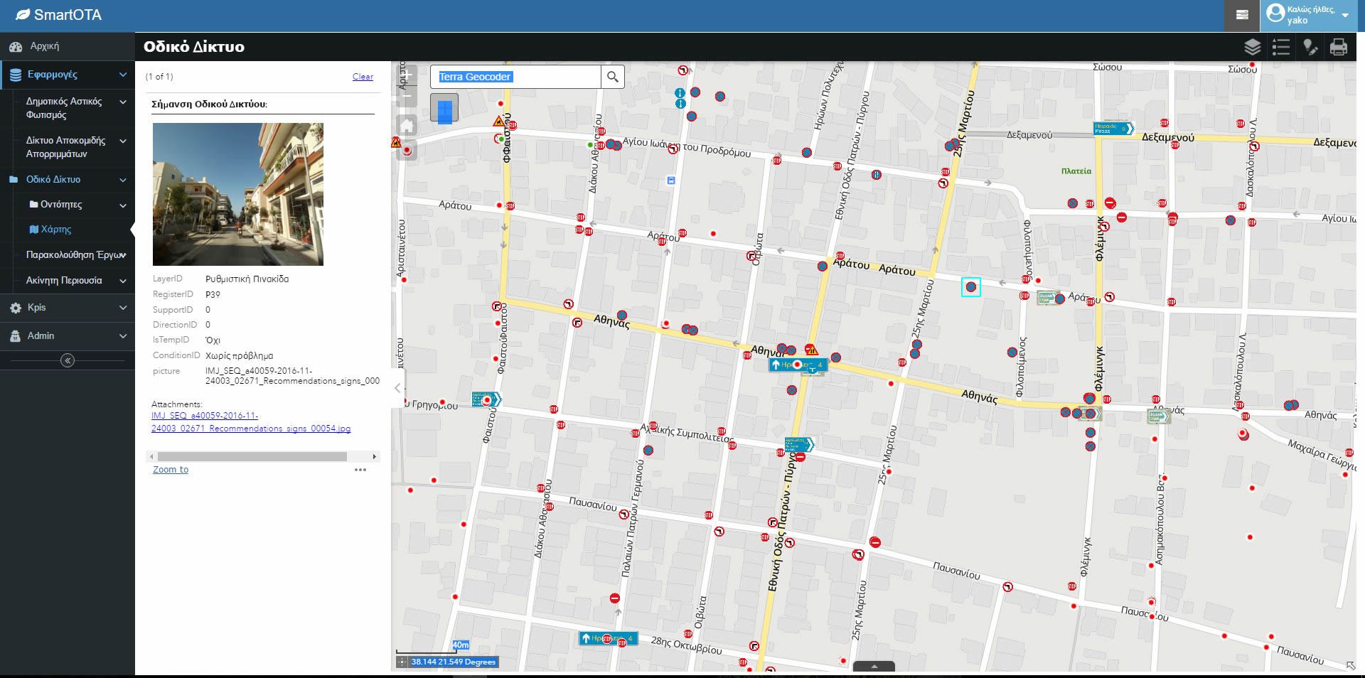
- Traffic Management and Signage: record road signage on your municipality’s boundaries and implement maintenance activities to help drivers by providing an more efficient traffic flow management and identifying illegal billboards
- Public Spaces Management: record and describe the public areas of your municipality in order to meet important needs such as (a) the regulation of licensing terms for the occupation of communal spaces with table chairs, (b) the imposition of fines and penalties in case of violation of public areas use conditions, (c) supervision and protection, (d) special care in green areas with emphasis on cleanliness, plant care, further afforestation where this is possible (e) rapid and effective treatment of problems by simplifying the bureaucratic process and internal co-operation among the municipality’s services
- Real Estate Management: take advantage of the SmartOTA “Real Estate Property Register” to register your real estate assets for real estate optimization as one of the most important sources of the municipality’s revenue services. Submit the property data (address, area, other features), tenants’ data, lessors, calculate rents based on current market prices and check receipts and outstanding amounts. At the same time, as far as financial management is concerned, calculate via Property Register functionalities municipal taxes, adjustments, objective values, trading values, estimates and maintenance costs
- Urban Planning: homogenize your urban and city planning information into a Geographic Information System and enable municipal planning and implementation staff and citizens (individuals and engineers) to have direct, valid and up-to-date information on public geospatial and descriptive data
- Utilities: Obtain overall supervision of the infrastructure of your water supply, drainage and storm water networks, Record and monitor corrective and intervention remediation actions and plan preventative maintenance activities
- Pumping stations and drilling: the operation of the pumping stations, especially in the provincial municipalities, and more specifically the pumping of water, is one of the most energy-consuming tasks. It has been proven that proper study, recording and operation of existing equipment can dramatically upgrade the processes and save costs to achieve depreciation even within two years. These interventions ensure (a) the reduction of thermal losses due to inaccuracies, (b) the reduction of losses due to harmonics, (c) the increase in equipment efficiency, (d) the reduction of the recorded maximum demand for power in the accounts of HEDNO (ΔΕΔΔΗΕ) and (e) energy savings from the use of equipment and the charges of the HEDNO (ΔΕΔΔΗΕ)
- Civil Protection: Prevent and respond to emergencies using the SmartOTA subsystem functions. (A) prepare for event management by simulating and studying similar events in the past, interventions in planning and updating / upgrading available resources, (b) supporting your actions from the ongoing monitoring of the event, (c) informing citizens beforehand as well as after the event
This platform is used by DEPAN (Network of Greek Cities for the Development), which consists of 15 municipalities – members of the network.